To understand declination you must first realize that there are two North Poles.
A compass always points toward the Magnetic North Pole. Maps are oriented to the True North Pole. The difference between True North and Magnetic North is called declination.
Declination varies from 0 to 30 degrees in most populated regions of the world. These declination values usually change slightly over time, as the earth's plates shift. The actual value of declination and its annual rate of change for your area will usually be shown on your map. This will be expressed as either an Easterly or Westerly declination, depending on your location.
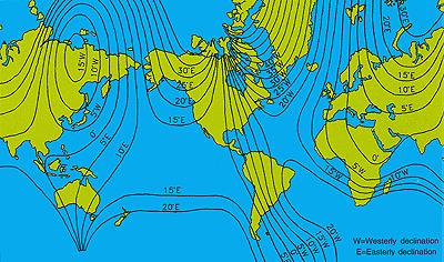
This is an actual declination chart from 1990, showing the worldwide declination situation in 1990. The current declination values for today will be very close, if not identical, to the values on the right.
The correction for declination is easily made. Once you have aligned your compass on the map in your direction of travel, and rotated the capsule to match the map's North-South directions, you are ready to make adjustments for declination.
At this point, you simply subtract Eastern declination from or add Western declination to this direction and turn the capsule so that the new direction aligns with the index mark at the top of the baseplate.
Some compasses have an adjustable declination correction scale that will allow for the declination compensation. With this type of compass, the true direction can be used directly from the compass.
Before buying a compass, you may want to consider whether it has a fixed declination correction scale, or an adjustable declination correction scale.